WatchSat › Blog › How do weather satellites work? Orbits, sensors and data
How do weather satellites work? Orbits, sensors and data
How weather satellites work: geostationary imagers 35,786 km up scan a full disc every 10 minutes, and low orbiters supply over 80% of forecast model data.
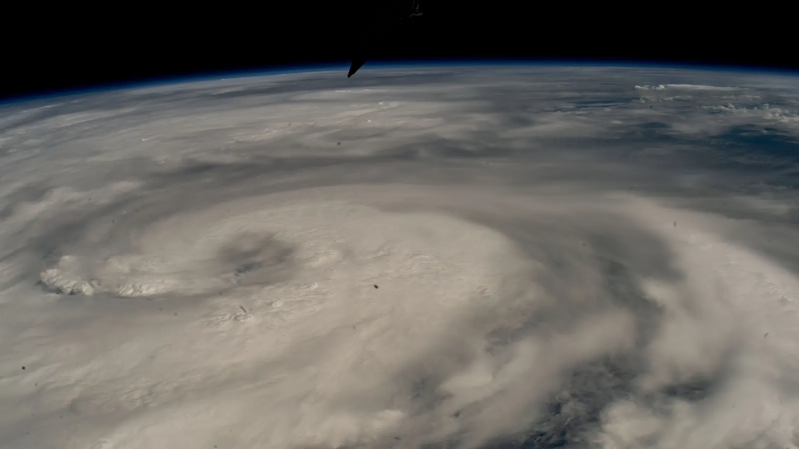
Weather satellites work by measuring the light and heat rising from Earth's clouds, air, land and sea, each in its own narrow band of wavelengths. Geostationary satellites sit 35,786 km above the equator, the height at which one orbit takes as long as one turn of the Earth, so each stays over the same spot. The newest of them scan the whole face of the planet below every 10 minutes. Polar orbiters fly far lower, at about 820 km, passing close to both poles and building up a picture of the globe one strip at a time. The choice of orbit sets how often a satellite sees a place and how much detail it gets.
Instruments record each of those bands as a separate channel. Visible channels record sunlight bouncing off clouds and ground, so they go blank at night. Infrared channels pick up the heat that clouds, land and ocean give off themselves, which keeps the pictures coming in the dark. Because colder cloud tops are higher, the coldest patches in an infrared image mark the tallest storms. Water vapor channels use wavelengths that moist air absorbs, and the images they make show moisture in the middle and upper atmosphere rather than the ground.
An imager turns channels like these into pictures. The Advanced Baseline Imager (ABI) on the US GOES satellites records 16 channels at 0.5 to 2 km resolution, NOAA presentations show. A sounder works differently. It measures many closely spaced wavelengths, each sensing a different depth of air, so forecasters can work out temperature and humidity at different heights.
What is the difference between geostationary and polar weather satellites?
Because it keeps pace with Earth's rotation, a geostationary satellite watches the same disc of the planet nonstop, as our geostationary orbit explainer describes. NOAA made GOES-19 its GOES East satellite on April 7, 2025, replacing GOES-16. GOES-18 is GOES West, The Weather Network reported that month, and our snapshot puts GOES-18 at 137.0 degrees west.
The drawback is distance. By our geometry, the line of sight stretches from 35,786 km straight down to 41,679 km at the edge of the visible disc, so detail fades toward the poles. One satellite can't see more than 42% of Earth, which is why there's a ring of them.
Geostationary imagers make up for it in frequency. Since April 2019 the ABI's default mode has scanned the full disc every 10 minutes and the continental US every five, according to NOAA's GOES-R program, which covers the current series of GOES satellites. It also scans two small boxes over active weather every 60 seconds, or one every 30 seconds. Japan's Himawari-9, operational since December 13, 2022, covers its full disc every 10 minutes and target areas every 2.5 minutes, the Japan Meteorological Agency says. The current GOES satellites also carry a Geostationary Lightning Mapper (GLM). According to a 2018 National Weather Service workshop talk, it maps total lightning, both in-cloud and cloud-to-ground, continuously and at about 8 km resolution over most of the Western Hemisphere.
Polar orbiters trade that constant view for closeness. In our data the 21 sun-synchronous ones fly 811 to 844 km up. Like CelesTrak's catalog, we measure height from Earth's equatorial radius of 6,378 km. NOAA-20, at 827 km, is about 43 times closer to the ground than a geostationary satellite. It laps Earth 14.2 times a day, and because Earth turns beneath it between laps, each lap crosses the equator 25.4 degrees of longitude, or 2,823 km, farther west. Its instruments sweep a fresh strip each time. Most of these satellites are sun-synchronous, meaning they pass over each latitude at the same local time by the Sun every day, as our sun-synchronous orbit explainer describes.
NOAA-20 and NOAA-21 each carry four instruments, according to NOAA. VIIRS is the imager, ATMS and CrIS are sounders working at microwave and infrared wavelengths, and OMPS measures ozone. You can check NOAA-20's passes over your location or the pass predictions for Suomi NPP, another NOAA polar orbiter.
| Geostationary | Polar (sun-synchronous) | |
|---|---|---|
| Height | 35,786 km | 811 to 844 km in our data |
| One orbit | 23 h 56 min | 101.1 to 101.8 min |
| What it sees | the same 42% of Earth, nonstop | a new strip on each lap |
How much of a weather forecast comes from satellites?
A forecast model is a computer program that steps the atmosphere forward in time from a starting picture of temperature, moisture, wind and pressure around the world. NOAA's satellite service, NESDIS, says satellites in low Earth orbit supply more than 80% of the data that numerical weather prediction models use for forecasts three to seven days ahead. The figure counts only the low orbiters, and it measures their share of the data going in.
Their effect on accuracy is measured another way, by how much each kind of observation cuts the errors in a forecast. A study presented at a 2012 World Meteorological Organization workshop credited satellite observations with about 64% of that error reduction for short-range forecasts. Europe's Metop and NOAA's polar satellites together gave about 58% of the impact of all observations. The study is 14 years old and used earlier instruments, though its results point the same way as NOAA's figure.
Weather satellites in our October 11 snapshot
We searched our October 11 snapshot of CelesTrak's active list, the 16,701 objects behind our live satellite map, for dedicated weather satellites by name and found 50, or 0.30% of the list. They include retired and standby craft, since the list keeps anything that's tracked and not known to be dead. Of the 50, 27 are geostationary and 22 fly in low orbit, 21 of them sun-synchronous. The odd one out, Russia's Arktika-M 1, swings between 719 km and 39,633 km on a stretched 12-hour orbit.
China and the United States fly the most, 13 each. China's are five geostationary Fengyun satellites and eight Fengyun-3s in low orbit. Seven of the American 13 are civil satellites run by NOAA, and the other six carry military names. Three belong to the Defense Meteorological Satellite Program (DMSP), one is the Space Force's WSF-M, and two are former GOES satellites now listed as EWS-G2 and EWS-G3. Behind them, EUMETSAT, Europe's weather-satellite agency, and Russia have nine each, India three, Japan two and South Korea one. On WatchSat you'll find them under other satellites.
The 27 geostationary ones occupy 21 slots, and some slots are crowded. Meteosat-12, MTG-S1 and Meteosat-10 sit within 0.55 degrees of one another around zero longitude, a spread of about 405 km. Japan keeps its backup, Himawari-8, 88 km from the working Himawari-9. Elsewhere the ring has wide gaps. The widest is 60.8 degrees of longitude, over the Atlantic from GOES-19 to Russia's Elektro-L 2, and the next is 57.2 degrees, across the Pacific. Even so, no point on the equator is more than about 30 degrees of longitude from a weather satellite's sub-point, the spot directly beneath it.
In low orbit, 21 of the 22 are sun-synchronous, their orbits tilted 98.5 to 99.0 degrees against the equator. China's Fengyun-3G, at 404 km and 50 degrees, is the exception. We worked out when each one crosses the equator in mean local solar time, the time of day set by the Sun's average motion at that longitude. The results, good to a few minutes, show three clusters. An early-afternoon group of NOAA-20, NOAA-21, Suomi NPP and China's Fengyun-3H crosses northbound between 13:25 and 13:38. Metop-C and Metop-SG-A1 take a mid-morning slot, crossing southbound at 09:28 and 09:29. Fengyun-3E, DMSP F17 and WSF-M fly dawn-dusk orbits along the line between day and night, crossing southbound between 05:46 and 06:03.
MTG-I2, about six weeks old, is the newest on the list. Among the GOES satellites, the oldest is GOES 14, which the catalog lists as "EWS-G3 (GOES 14)". Its international designator, the catalog code that starts with the launch year, dates it to 2009. The oldest GOES with a documented job is GOES 15, launched in 2010. Spaceflight Now reported in September 2020 that it had become EWS-G2, covering the Indian Ocean for the US military.
The newest weather satellites and what comes next
Meteosat-12, the first Meteosat Third Generation (MTG) imager, entered service in December 2024 at the end of its commissioning, the checkout period after launch, according to WMO's satellite database. Its sounder counterpart, MTG-S1, launched on July 1, 2025, Spaceflight Now reported. ESA says the first Metop Second Generation satellite, Metop-SG-A1, followed on August 13, 2025, with six instruments including the first Copernicus Sentinel-5. The second MTG imager, MTG-I2, lifted off on August 27, 2026, and ArianeGroup's launch kit says it's due to scan Europe every 2.5 minutes.
In the US, GOES-19 was the last of the GOES-R series. Its successor, GeoXO, is still planned to start launching in 2032, NOAA said in an August 2026 update. The program has shrunk from six satellites to four, carrying only an imager and a hyperspectral infrared sounder, which splits infrared light into very narrow channels. Instruments for ocean color and atmospheric composition were cut, and so was GeoXO's lightning mapper. The first satellite is to carry a GOES-R-style ABI. The next three, planned for 2034, 2039 and 2043, would carry a new GeoXO Imager. In July 2026 the Congressional Research Service said it's unclear whether the changes will move the launch date.
The next US polar orbiter is due sooner. NASA's JPSS page says JPSS-3 and JPSS-4, the next satellites in the Joint Polar Satellite System, are in development for launch-readiness dates in 2027 and 2032. In Europe, ESA plans Metop-SG as six satellites flying in successive pairs for at least 20 years. The second, Metop-SG-B1, is listed for no earlier than November 30, 2026, on Launch Library, the database behind our launch schedule, though the date is still marked to be determined.
Sources
- NOAA NESDIS, NOAA's GOES-19 now operational as GOES-East, providing critical new data to forecasters, April 7, 2025
- NOAA/NASA GOES-R Program, Advanced Baseline Imager (ABI), scan modes, undated
- T. Schmit, NOAA STAR, seminar slides on the GOES-R Advanced Baseline Imager, 2014
- National Weather Service, Geostationary Lightning Mapper workshop presentation (Lindstrom), 2018
- The Weather Network, Brand new satellite to begin watching over Canada into the 2030s, April 2025
- Japan Meteorological Agency, AOMSUC-13 abstract on Himawari-9 operations and AOMSUC-12 presentation on Himawari observation schedules, undated
- NOAA NESDIS, Near Earth Orbit Network (NEON), undated
- NOAA Satellite Information System, Joint Polar Satellite System, undated
- NASA, JPSS mission page, accessed October 11, 2026
- WMO, forecast-sensitivity presentation (Joo), workshop on the impact of observing systems on numerical weather prediction, Sedona, 2012
- Spaceflight Now, NOAA weather satellite transitions to new role for U.S. military, September 13, 2020
- WMO OSCAR, Meteosat-12, undated
- Spaceflight Now, EUMETSAT, ESA to launch combo MTG-S1/Sentinel-4 satellite on SpaceX Falcon 9, July 1, 2025
- ESA, First MetOp-SG and Sentinel-5 launched, August 13, 2025; MTG-I2 is launched from Europe's Spaceport, August 27, 2026
- ArianeGroup, VA270 launch kit, August 2026
- NOAA NESDIS, GeoXO User Readiness Update, August 2026
- Congressional Research Service, IF12898, on the GeoXO program, updated July 24, 2026
- CelesTrak, active satellites element sets, WatchSat snapshot of October 11, 2026
- The Space Devs, Launch Library 2, upcoming launches as loaded on October 10, 2026
Follow by RSS. Share this post: Bluesky · X · Reddit · Email
More from the blog
-
What are the types of orbits? LEO, MEO, GEO and HEO
The main types of orbits are LEO, MEO, GEO and HEO. Of 16,701 objects on CelesTrak's active list on October 11, 2026, 95 percent were in low Earth orbit.
-
What are the Van Allen belts? Altitude, risks and satellites
The Van Allen belts are two zones of trapped particles, about 1,600 to 40,200 km up by NASA figures. Of 16,701 active satellites, 95% stay below 2,000 km.
-
What is a geostationary orbit? Height, speed and delay
A geostationary orbit is a circle 35,786 km above the equator where a satellite keeps pace with Earth's spin and seems to hang still. We counted 573 there.
-
How many GPS satellites are there? Height and how GPS works
The U.S. Space Force counted 32 operational GPS satellites in April 2026, about 20,200 km up. How GPS works, and how Galileo, GLONASS and BeiDou compare.
-
How fast does the ISS travel? Speed, altitude and orbit
How fast does the ISS travel? About 17,100 mph (7.66 km/s), circling Earth every 93 minutes 420 km up. Why it sinks, and how it gets pushed back up.

Home · Live satellite map · Satellite directory · Starlink · OneWeb · Navigation satellites · Space stations · Other active satellites · Track the ISS · ISS visible passes · Starlink train · Rocket launches · Aurora forecast · Humans in space · Solar System · Deep Space · Embed widgets · Blog · Guide: spot the ISS · Guide: what is a TLE? · Guide: how many satellites? · Guide: satellite trackers compared · Discovery: Elias 2-24 b · About · FAQ · Data & methodology · Credits · Editorial policy · Accessibility · Contact · Privacy · Terms
© 2026 WatchSat · Not affiliated with any space agency or satellite operator.